A couple of weeks ago, on Wednesday, I decided to leave my campsite outside of Zion and head back to San Diego. I spent the majority of the time with family and friends, running out to McCain Valley Recreation Area and Carrizo Gorge Wilderness to hike to Peak 3339, Gasp Benchmark, Groan Benchmark, and Rozzie Mountain. Finally, yesterday, I made my way back to camping out on the Carrizo Badlands Overlook for the week.
While staying outside of Zion, I received a notice that my new Pixel Phone by Google had come into my mailbox. Unfortunately, I could only have the package forwarded by UPS, so I decided to contact family in San Diego and make the days long drive there to pick up and activate my phone. As such, I ended up bouncing between family and friends for the next week and a half or so. Of course, finally being in San Diego again, I had to go do some of the peak bagging that had not made my list last time I was near.
Peak 3339
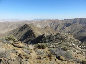
On the northern side of McCain Valley Recreation Area lies the Carrizo Overlook–not to be mistaken with the Carrizo Badlands Overlook in Anza Borrego Desert State Park. This makes for a wonderful trailhead with a very interesting system of trails going over several overlooks, looking out to the desert below.
 I had previously done a hike on these trails myself, but I had not gone the correct route for approaching peak 3339. On the previous venture, I had kept going straight, whereas this time, I kept left as much as possible. Continuing to keep left, the route eventually took me to the northeast side of Peak 3339, where I decided to turn back a short ways before making a cut across the desert towards the peak.
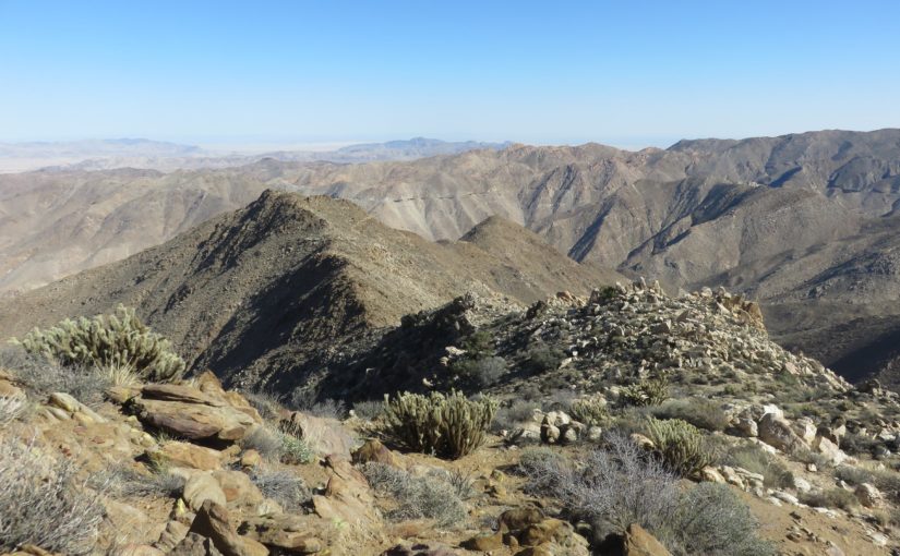
This route really turned out to be quite awful as an option. The trail out was easy, going downhill and easy enough to traverse almost the entire time. The off-trail route started easy enough, but turned into quite the more difficult scramble up the boulders lining the mountainside. It wasn’t until I had reached nearly the ridge line of the peaks that the hiking became easier again, with views opening back up out to the desert and only a light scramble remaining to the actual peak, called Peak 3339 for being at an elevation of 3339ft.
 I didn’t spot any register or other notable thing on the peak, but looking at GPS and topo maps, it was quite clear that I had reached the appropriate summit. Nonetheless, I sat and stared out at the views for a short time before trying to find an easier, quicker route back down the mountain towards the trail once more.
Thankfully, I found a very easy route back down the mountain. Only very light scrambling over some larger rocks was required, but mostly, it was just a direct route across the desert before I hooked back up to the trail that I began on. From there, it was then a slog uphill on the trail back to the trailhead.
Overall, the hike was 7.8 miles, with about 2375ft of cumulative elevation gain. Particularly including the more difficult scrambling that I got myself into, it would easily be rated as a more difficult hike for most, although it wasn’t quite so bad for me!


Gasp Benchmark, Groan Benchmark, rozzie mountain
The week after my hike of Peak 3339 was Thanksgiving week, so I continued to spend time with family in the area. I stayed with my parents on their boat, enjoying Thanksgiving with them, and going out boating on the water with them.
On “Black Friday”, it was then time to set out for another hike, instead of dealing with the madness of everyone hitting the stores–besides my favorite stores were closed for the #optoutside campaign anyway. This time, on the southern side of McCain Valley Recreation Area, where access to the Carrizo Gorge Wilderness can be found. The wilderness was designated by the US Congress in 1994, and contains some of the most expansive viewpoints in the entire desert. It also looks down into and contains some of the Western rim and slopes of Carrizo Gorge itself, a wonderful canyon perhaps best known for the railroad traversing the Eastern side. The wilderness, itself, encompasses a wonderful, protected area of transition between the San Diego’s coastal mountains and the Colorado Desert below.
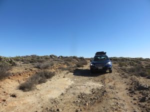 I began Friday morning by driving out to the Socotone Overlook along the dirt roads, exploring more of the McCain Valley Recreation Area that I had previously neglected to explore. I quickly learned that Google Maps lines out quite a number of roads that don’t actually exist, at least not for driving purposes. That would prove alright nonetheless, as I parked at an obvious place I spotted and set out on my hike.
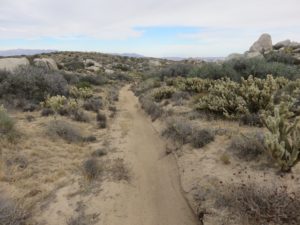
The hike began along what was essentially a dirt road, although it was well gated and blocked off from every angle. As I continued down proper directions, the road narrowed into trail, and the scenery felt more and more remote.
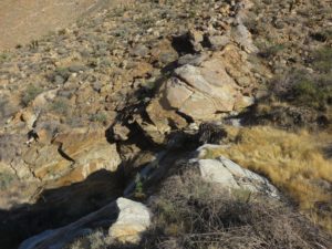
 Before long, the white sand I was walking on turned suddenly to darker rock, and the trail ended, turning my hike into ridgeline traverse. The route remained quite obvious, as only forward or backward really seemed to exist any further. Some light scrambling exists along the route, but the route remained easy to follow and not remarkably difficult to traverse by any means.
Finally, I reached the area of Gasp Benchmark. I found the trail register easily, although I couldn’t spot the benchmark itself. The trail register was covered in spider webs, and I decided not to bother signing in, simply moving on down the ridgeline further towards Groan Benchmark.
 The hike down the ridgeline was simple, but a low point appeared obvious when I was just north of the Groan and the ridgeline turned into more of a boulderous outcropping akin to the nearby Jacumba mountains on the opposite side of the Carrizo Gorge. From here, I dropped down into the wash on the southern end of the ridge, finding a nice crossing atop a dry waterfall.
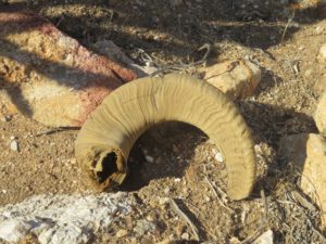 This was the low point of the entire hike, and the most difficult climb so far began immediately after. This turned into a steep slog, and occasional scramble up the hillside towards Groan Benchmark. The views were much less remarkable than those I had seen previously along the route, but interestingly different. I even spotted a horn from a borrego lying on the ground in this section, likely from one of the few herds that call this remote area home.
Alas, I reached the benchmark on top of the peak. I found a benchmark that incorrectly was labeled “Moan” (moan benchmark actually existing on the opposite side of Carrizo Gorge, among the Jacumba Mountains), but could not find a trail register there. So, I continued on once more, dropping down along this new ridgeline towards Rozzie Mountain.
While making this drop, I began watching the time and realized something somewhat terrifying: the likelihood of getting to even a trail or dirt road before sunset was dwindling. I had miles of cross-country traveling to continue, and to finish before sunset would take a pace that would be fast for even a well developed trail. Nonetheless, I continued up to Rozzie Mountain summit.
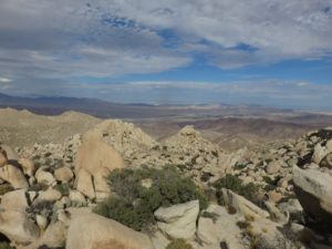
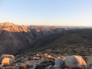 Atop Rozzie Mountain, the views were amazing, but the evidence of sunset arriving was all too clear. I sent a quick text message to family, notifying them of where I was and my projected route, with a new plan to contact them as soon as I was safe. Although it is generally good practice to do so in the first place, knowing that I would be traversing more dangerous ground via headlamp was enough to solidify the precautions regardless.
So, I continued on. I had a track of another person who had hiked a similar route on my GPS, and I began trying to stick closely to that. The route would take me up to the summit of Mt Tule, which I had previously completed nearly a year ago. I assumed that in the worst case scenario, I at least had the hopes of being able to safely follow another person’s similar traverse.
From Rozzie Mountain to Mt Tule, there was first a drop into a valley, covered in the diversity of species from the coastal mountains and Colorado Desert together in the area of transition. The cacti continued proving a hazard, only getting more difficult as the sunset and darkness set in. I turned on my headlamp, finally, as I neared the end of the flats and began the climb up the steep slopes of Mt Tule.
As twilight finally ended and I found myself only a short way up the slopes, I encountered yet another problem: the batteries on my headlamp died, and I quickly found that I had brought along the wrong batteries for it. The moon had still not neared rising yet, and the route was nearly impossible to see forward. I took out my phone and began using it as my flashlight.
Although the GPS route I was following seemed to be doing okay, as close as I was able to follow it without constantly looking at it, I decided to forget following it all of the way to the summit of Mt Tule, and I began making a different route along the Northern slopes of the mountain instead. A climb was still required to traverse over the ridgeline, and I no longer had a reasonable GPS route to follow, but I pushed on through more difficult scrambles and thick, thorny chaparral brush. If any positive was felt at that moment, it was the lack of cacti, finally.
Finally, I reached back to the descending route of the GPS route I was following, and quickly found the dirt roads once more. The hiking finally became reasonable and easy, even for a night hike. There was still a good mile to mile and a half, but being along dirt roads made it seem far more reasonable than the scrambling and bushwhacking before.
Making it back to the car, I called family and headed back to stay with them for the night, stopping only to buy some beer and In-N-Out along the way. I certainly slept wonderful that night, after that exciting hike!
The hike proved to be an 11.2 mile slog with about 5610ft of cumulative elevation gain. Especially with the scrambling and difficult terrain involved, it makes for one strenuous hike!
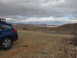 Of course, I couldn’t stay with family forever, and Sunday night, I needed to go out and find a good place to stay. Earlier in the year, I had spent a long time at the Carrizo Badlands Overlook in Anza Borrego Desert State Park, and it was a spot I absolutely loved. Upon looking at weather reports, I saw that it would prove to be a wonderful spot to stay at once more, and so I headed there to set up camp for the week. The adventures for 2016 are coming to a more quiet conclusion over the next month, but this should provide an awesome base for doing yet more of the long list of hikes I have to do around San Diego.


