Indian Flats, Caliente Wilderness, to Combs Peak (09-27-2014)

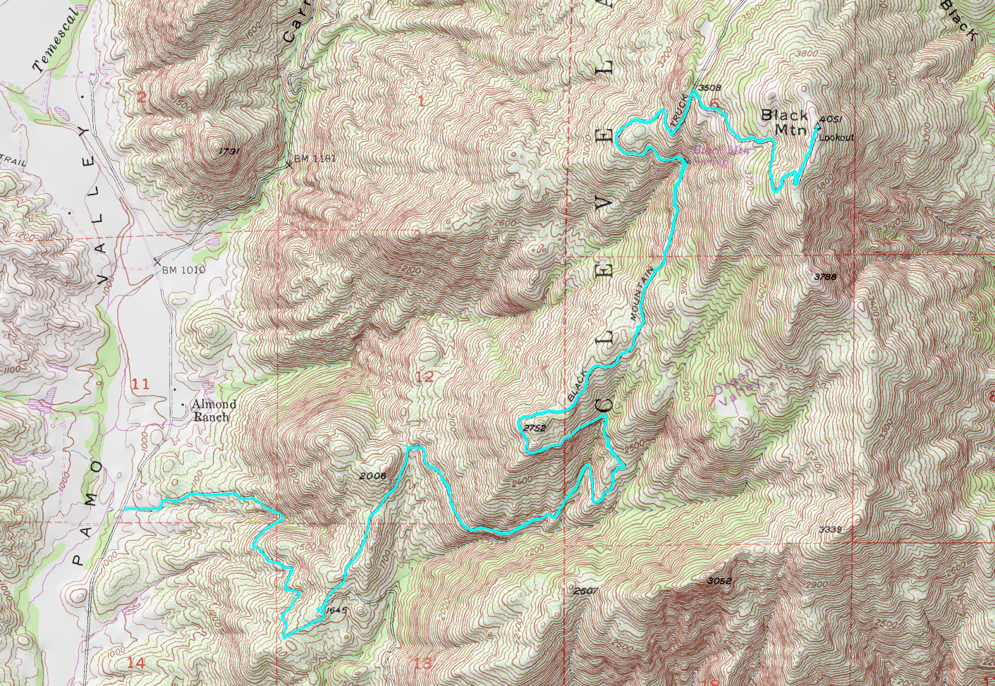
Location: Indian Flats Campground, Caliente Wilderness area in Cleveland National Forest, near Warner Springs, CA; Combs Peak in Anza Borrego Desert State Park
Difficulty: Strenuous (Could be done in sections of Moderate to Difficult)
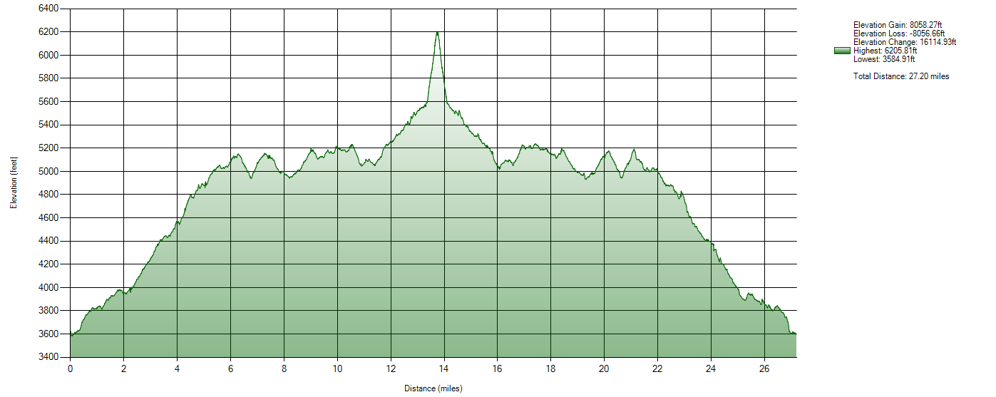
Hike Statistics: 27.2 miles, over 16,000ft of cumulative elevation change (over 8,000ft gain)
Conditions: Cold to Cool, Mixed Shade (40s-80)
Requirements: Adventure Pass if parked in Cleveland National Forest area, except Indian Flats which is a separate Fee Area; no requirements if parked in Anza Borrego Desert State Park section
Trailhead: Indian Flats Campground33.329945, -116.640359 Cleveland National Forest near Warner Springs, CA connection to Pacific Crest Trail near Caliente Wilderness area; 33.381567, -116.595134 Anza Borrego Desert State Park, Last Valley Road and Pacific Crest Trail junction near Combs Peak

Sierra Club 100 Peaks List: Combs, #001

GPX Track: Google Drive (Note: Accuracy Not Guaranteed)

Map of Hike
Map of Hike
Elevation Profile of Hike
Published
Categorized as Pre-Nomad

“Big” Black Mountain (09-20-2014)

Enjoying the summit breeze

Location: “Big” Black Mountain, Cleveland National Forest, near Ramona, CA
Difficulty: Strenuous (technically possible to make easier)
Hike Statistics: 14.5 miles, over 8,000ft of cumulative elevation change (over 4000ft gain)
Conditions: Comfortable, Mixed Shade (60s-80s per forecasts)
Requirements: May need Adventure Pass, deepending on parking location
Trailhead: 33.140460, -116.850113 ; on Pamo Road in Cleveland National Forest

Sierra Club 100 Peaks List: Black #1, #44

GPX Track: Google Drive (Note: Accuracy Not Guaranteed; Only includes hike described below)

Map of Hike
Map of Hike
Published
Categorized as Pre-Nomad

El Cajon Mountain, El Capitan Open Space Preserve (09-13-2014)

El Capitan Open Space Preserve sign at Trailhead (taken at end of my hike)

Location: El Cajon Mountain, El Capitan Open Space Preserve, Lakeside, CA
Difficulty: Strenuous (Moderate to Difficult hikes technically possible)
Hike Statistics: 11.87 miles, over 10,500ft of cumulative elevation change (over 5200ft gain)
Conditions: Pre-dawn start. Temps ranging upper 60s at the start to 100 on return. Very sparse shade on return.
Preserve Hours: 7am to roughly sunset (closing time is posted). Some parking space along road for earlier starting times (recommended in hot conditions). Preserve is closed the entire month of August due to extreme heat.
Trailhead32.912545, -116.884734 ; off of Wildcat Canyon Road, across from Oak Oasis Open Space Preserve

Sierra Club 100 Peaks List: El Cajon, #89

GPX Track: Google Drive (Note: Accuracy Not Guaranteed; Only includes hike described below, does not include additional trail options)

El Capitan Open Space Preserve sign at Trailhead (taken at end of my hike)
Mapped route of my hike
Published
Categorized as Pre-Nomad

Hot Weather Hiking!

I have often talked to some people, posting on Facebook and in discussion, about how I survive hiking in hot weather. From small, local San Diego hikes to the Grand Canyon where I faced temperatures over 100 degrees Fahrenheit, to one day on a Pacific Crest Trail section hike where temperatures were over 110 degrees Fahrenheit with no shade in sight for many miles. Through all of this, I’ve picked up a lot of techniques, which I have practiced and modified, and continue to practice and modify. As this knowledge is useful, I am writing this post to describe some of what I have learned.

Published
Categorized as Techniques

Foster Point (09-10-2014)

Foster Point sign at nigh

Location: Foster Point, Mt Laguna, CA
Difficulty: Easy
Hike Statistics: 1.4-1.5 miles round trip; about 200ft elevation change
Conditions: Night, high 50s to low 60s; Clear sky, bright moon
Requirements: National Forest Adventure Pass (Cleveland National Forest) ; Required on car to park in the area
Trailhead: 32.889452, -116.441021
GPX Track: Google Drive (Note: Accuracy Not Guaranteed; Only includes attempted drawing of route via satellite images and was not actually taken from a GPS device in any way)

Google Earth Mapped Route
Published
Categorized as Pre-Nomad

Hellhole Canyon Open Space Preserve (09-06-2014)

View into the canyon and up Rodriguez Mountain at the start

Location: Hellhole Canyon Open Space Preserve, Valley Center, CA
Difficulty: Easy to Difficult
Hike Statistics: 9.2 miles, 7320.54ft elevation change (3658.69ft gain)
Conditions: 90s to 100s, Mixed shade/no shade
Preserve Hours: Friday – Monday, 8am to Sunset. Preserved closed Tuesday, Wednesday, and Thursday. Closed entire month of August due to extreme heat.
Trailhead33.216444, -116.934028
GPX Track: Google Drive (Note: Accuracy Not Guaranteed ; Only includes hike described below, does not include additional trail options seen in image below)

Blue Line represents GPS Plot of my hike. Yellow lines represent additional/alternative routes
Elevation graph from GPS plot
Published
Categorized as Pre-Nomad

August 2014 Pacific Crest Trail Section A San Diego

On August 22, 2014, I drove down to San Diego. After staying with my parents for a night, they drove me the US/Mexico border south of Campo, California. At the Pacific Crest Trail trailhead, I began hiking. Over the next 8 days, I hiked 138 miles (plus 4 miles hitchhiked from Ranchita, CA back to the trail) to Indian Flats Campground in the Cleveland National Forest north of Warner Springs, CA. The final day, a friend picked me up from the campground and drove me back home after a good cheeseburger and slice of Julian baked pie. On Sunday, August 31, I then walked to the Vista Transit Station, where I hopped onto the Sprinter to the Oceanside Transit Station. My parents had sailed their boat up to the Oceanside Harbor, where I stayed that night. On Labor Day, September 1, we then sailed the entire day back to San Diego, where I picked up my car and drove back home.

Published
Categorized as Pre-Nomad