While doing research on hikes in the PNW further, I ran into the Loowit Trail, which circles all of the way around Mount St Helens. A couple of years ago, I visited this mountain for the first time and fell in love with it in a special way, so I was especially excited to see what this was. After reading tons about it being a remarkably difficult hike “for experienced backpackers”, I heeded some caution but headed in. I spent the weekend of August 3 circumambulating Mount St Helens on the Loowit Trail.
Now, for this hike, a lot of the research I did cautioned people to leave it to experienced backpackers. In a large way, I still have no idea what that recommendation even actually means. I never really write my trip reports as anything like a guide for the trail any more, so I’m not going to spend time worrying about what that does mean. Nonetheless, whatever it means, it is probably good advice for this one. Make your own choices, take your own responsibility. Hike your own hike.
The Pack
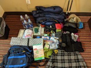
For this one, I finally ditched the whole waistpack plus daypack combo I’ve been doing for almost a year now. Instead, I picked up a Mountainsmith Day lumbar pack along with the Strapettes and used this as the sole pack.
I strapped the quilt to the outside in a drybag again, along with the sleeping pad, but was able to fit all of the rest of my gear and food inside of the pack. I definitely want to look at some continued tweaks to the system moving forward, but this really was a wonderful pack!
I don’t really care about baseweight these days, aside from an ongoing curiosity of tracking the changes I make and seeing what they actually achieve. That said, this pack came out to a baseweight of 8.25lbs. This lumbar pack, especially with the strapettes, is not a truly ultralight pack. But I also brought things like a super comfortable pillow, so how much do I really care about that? It would be nice to get that down in the future with yet more, better adjustments, but I think I’m in the sweet spot range for myself these days and don’t put a whole lot of effort into that aspect.
Day 1 : Friday
4.5 miles
During the week, I made my way to Woodland, WA and got a short stay in a hotel there. I found it to be a cute little town and a lovely area to stop and work for a bit. Thanks to having to check out of the hotel by noon, I even went and checked out Horseshoe Lake Park, which is a cool little community park in town on a horseshoe shaped lake. Even though it was gloomy as hell and seemed to be ready to rain any time it wanted, I enjoyed the stay in town, finishing up my work week before heading on up to the mountains.
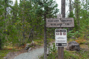
Alas! After what seemed like far too long to my ever anxious mind, I was satisfied with work, and I hit the road. About an hour away down some entertaining roads, I arrived at the Blue Lake Trailhead, found a spot to park, and gathered myself to hit the trail.
The trailhead started some vaguely different spot than appeared on my maps, and the mileage doesn’t really make sense between my map and my GPS in this one particular area. The rest was pretty accurate. To my understanding, there was a huge washout right there, which I walked through in finding my way to the Toutle Trail and continuing down it. Whatever that means.
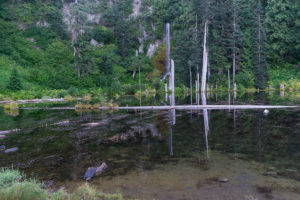
It wasn’t long at all before I crossed a small bridge over a creek that I stopped to laugh at. “On the Timberline, there weren’t any bridges!” As if that would be any indication of anything. But I laughed along and made my way to Blue Lake, which appeared photogenic… through the trees that completely blocked me getting a picture.
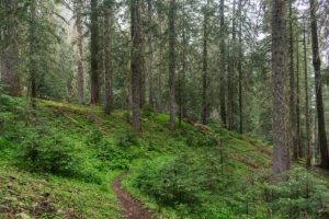
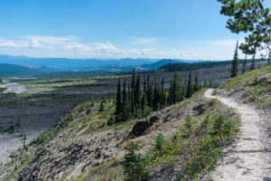
Continuing down the trail, I enjoyed the old growth forest along the Toutle Trail. Views of the mountain and really anything but the trail itself were obscured by the heavy mist and fog that made it feel almost like swimming through some mystical underwater dreamscape. It was simply magical.
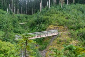
Stopping at Sheep Canyon, I noted how cold and clear the water was. If I hadn’t started full of water already, I would have been excited to find this stream and drink it. Perhaps take a dip on a warmer day. Even the real crossing, a wooden bridge suspended above a small cascade of the creek… There is this sense that this trail was purposefully made to be just beautiful. A sense that continued long into this hike.
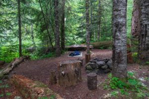
Finally, nearby another beautifully clear creek, I found a large, open campsite with a big fire ring. Everything was wet. Everything. Already, my socks and shoes were soaked. Every inch of the trail seemed to be covered in water and reaching out to share it with my feet. And it wasn’t looking like a very promising night for drying. Nonetheless, I spotted the driest spot I had seen all evening and set up camp, changing into dry socks, eating dinner, and enjoying a couple drams of scotch to see the forest to sleep.
Day 2 : Saturday
19.5 miles
Once again, I woke early on the trail and was packed up and headed out by 6:30-7am. After a short jaunt along the Toutle Trail, I finally met up with the Loowit. Just in time to repel down a cliff, clinging to a rope, ford the South Fork Toutle River, and climb the rope on the other side! Which went basically exactly how it sounds, actually. The first rope down was probably the easiest rope of the whole day: a nice introduction, I suppose.
Crossing the river: pretty easy. I splashed me feet a bit as I made one last jump to the other side, getting my feet and my socks wet. I stopped on the other side, inspected my other socks… also wet. All of my socks were about equally wet now. Not much else to do, I picked up, climbed the rope up the other side and carried on.
As I climbed and climbed, the ridge got sketchier and sketchier. Sandy and quite activating to my still ever present fear of heights, part of me felt it was absolutely stupid to stop and take any pictures. I stopped and took a ton of pictures. The views were even more beautiful than any of the intelligent fear I was feeling in my bones.
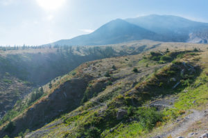
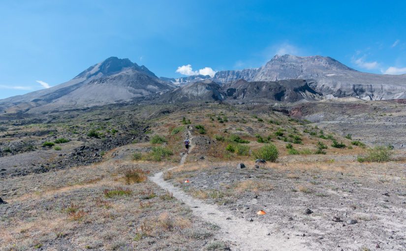
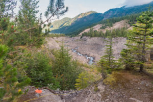
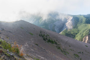
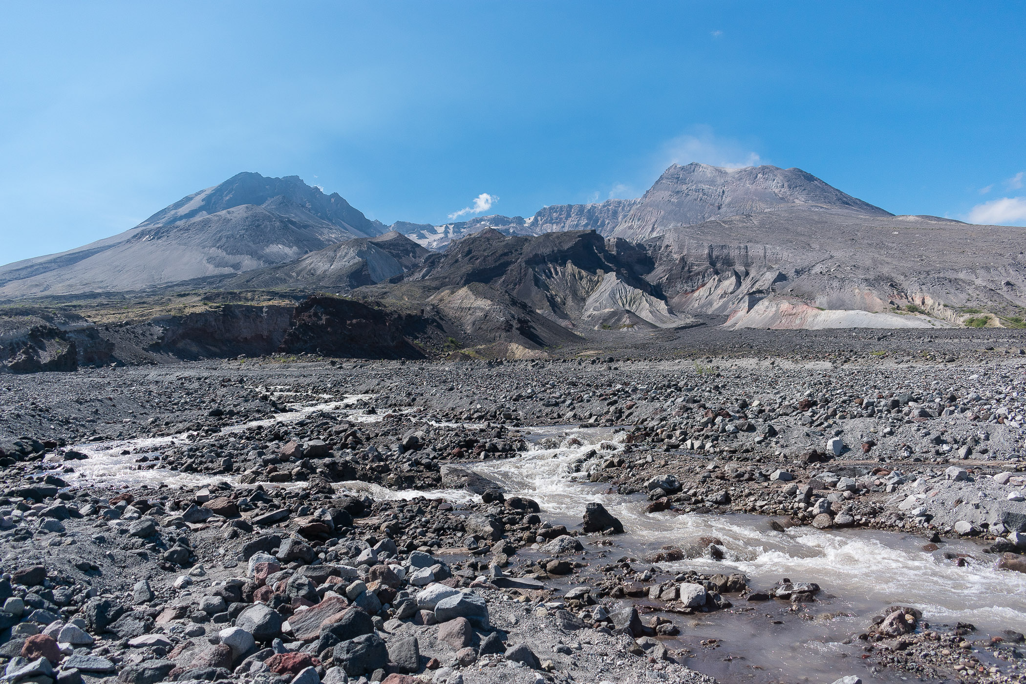
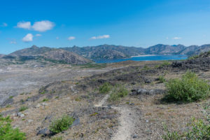
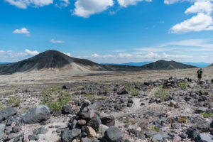
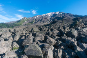
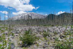
Finally on top of the ridge, aside from my constant stopping and gawking at how photogenic the trail itself was, especially with the backdrop of these massive canyons opening up below Mount St Fucking Helens, I began to enter the infamous blast zone. Technically, back down to the South Fork Toutle River shows plenty of effects from the 1980 eruption, but up on the ridge is where it becomes some kind of strange moonscape.
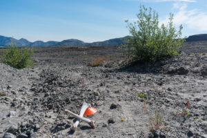
Along the way, somewhere before Studebaker Ridge, I desperately needed to take a squat. Unfortunately, it was pretty open, so I just tried to find a spot hidden behind a couple of trees. No one seemed to be on the trail behind me for a while that I had seen anyway, so it should be safe. But of course. A runner suddenly turned around the corner, right where I had not paid attention was looking right at me. Oy! And thus was my introduction to the fact that this day was also the day of the Volcanic 50k : a 50k ultramarathon on the Loowit Trail. On the upside: I had helpful orange cones the whole day to follow and some motivation from those badasses. On the downside: yeah, no solitude again. I just decided to make the best of it and chug along through the day.
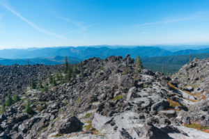
Hiking along, I really enjoyed the views of Studebaker Ridge before all of the runners started catching up, and passing on to the Floating Island Lava Flow just opened up more and more views throughout the blast zone and this ridiculously photogenic trail that bobs and weaves its way through. Even the crater itself began to open up along this section as the sun burned off the last of the fog and Loowit herself–the Klickitat name for this beautiful mountain–began to put on a show.
And of course just after all of this wonderful trail, it finally drops into an area that looks especially… blasted. Black lava rock lying everywhere, mixed with pumice and sand, and remarkably silty creeks coming down. I found it hilarious that a couple of bones were sat, crossed over one another as this section began.
This was a part that seemed to get more caution from those describing it as I researched it. However, I found it mostly quite easy. At times, the trail disappeared, but those red cones made it so easy, it didn’t matter. It took a little adventure out of it, but I didn’t really mind at the moment. The creek crossings were still quite adventurous, and I failed again to try to keep dry feet. But once again, all I had were wet socks anyway, so I kept hiking. And, well, that view!
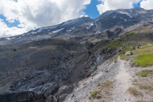
Finally hitting the junction with Willow Springs trail, I stared up at the crater and the trail climbing up Sasquatch Steps. Staring at the climb, I sat down at a clearing near the junction and ate some food and got some rest, watching as runner after runner continued past me on the trail.
I think Sasquatch Steps are appropriately named. It’s basically a climb up some really cool lava flow, like giant steps that the trail winds its way up. The whole way, views up to Loowit Falls were captivated, and any time I stopped to look back (which was often), the views to Spirit Lake and Mount Margaret were their own kind of captivating.
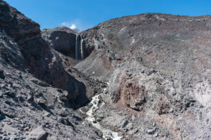
Reaching the junction to Loowit Falls, I decided to take the about mile-long round trip journey. The trail was basically exactly the same as the Loowit through this section: absolutely stunning but grueling, like the whole thing is. At the end, standing at the edge of the cliff looking at the falls was a reward worthwhile, though I only stopped momentarily before turning on. It’s a more popular day hiking destination on the mountain, so not even there could I find my solitude. Oh well.
Back on the Loowit, it was on to Windy Pass. Along the way, I passed by a small spring cascading down the trail, where some crew for the race had setup a water and aide station. Many of them were wearing astronaut costumes, which I found hilarious. I grabbed some water to filter and carried on through the bizarre plains up to windy pass.
Windy Pass wasn’t particularly windy for me, actually. There was a really nice breeze. Or maybe it is just because the climb sucked and was grueling. Another spot that got my fear of heights going again as the trail is quite narrow and not as sure footed feeling as one with such fears would hope. But at the top, a few runners gave me kind words about carrying a “40 pound pack”, which I laughed at as I caught my breath and enjoyed the view (my pack never actually weighed 40lbs, although it basically felt like it right there).
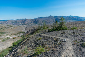
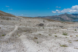
After a really sketchy drop down from Windy Pass, the stroll through Plains of Abraham was surprisingly cool. In some ways, it was not unlike much of what I had seen through other areas of the blast zone. In some ways, it was its own version of an alien planet transplanted awkwardly on the side of our own mountain. I saw a Mountain Goat up near Pumice Butte and stared in awe of the general scenes.
On the other side of Pumice Butte, aside from being constantly overwhelmed with yet more beautiful views, I caught up to a handful of the runners taking a rest at another aide station and even passed them by momentarily as I headed out towards the Muddy River, where dust devils lined the horizon and sometimes threatened to blow me right off the trail as the runners jumped back on and caught up to me.
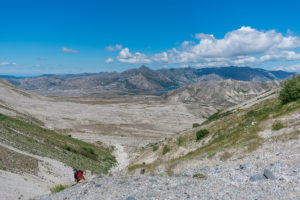
Talking to a ranger the weekend before, he had actually warned me that the area around the Muddy River sucked because of walking up and down these gorges of loose, ashy pumice and route finding through them. Of course, I was aided by the cones again, so route finding was simple, and the varied terrain just kept me absolutely thrilled with the trail. I thought the section was certainly grueling and truly difficult, but also really just beautiful and amazing. Like the whole damn trail.
And then came the beginning of the worm flows. This whole next bit was another section I had heard some cautions about in researching, talking about scrambling around a lot. I was grateful to find quite little scrambling between Muddy River and June Lake, but a sense of being on the edge of such, with the occasional route finding again aided by those stupid cones. It made the trail feel remarkably more rugged and difficult, but again… even the trail itself in this section was unbelievably beautiful and rewarding for the work. Like the whole trail.
In here, a lot of the runners were openly expressing a point of exhaustion and being ready to get the hell off the trail. I kept laughing: I was feeling the same damn way. My knees ached, my feet were still wet and uncomfortable as hell, and hitting 19 miles on this trail was surprisingly tough. I did run into one runner who was participating in a kilt! Apparently, he had heard I was out and was looking to catch up to me. He did. It was a lovely encounter.
Finally, I hit the junction with June Lake and took the way too goddamn steep trail down to the lake. With the waterfall falling in the background, an aged feel to the lake itself, and a good spot to setup camp under some bushes, I was happy to set down and rest! My feet were totally water logged and had started forming huge blisters, both of my knees ached with any movement, and the day felt somehow like one of the more grueling days I’ve hiked. I was happy to call it done.
Day 3 : Sunday
13.5 miles
I actually woke up pretty early on Sunday. The morning was ridiculously humid. Although I avoided any significant dew on me, all of my socks only felt more damp than the night before and there was a faint dampness to my quilt. I noticed that I was a little bit dehydrated and really should have just stayed in camp until that felt more resolved, but I was also hoping to escape the mugginess by the lake. I filled my water bottles, ate breakfast, and hit the trail by 7 again.
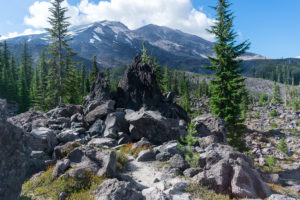
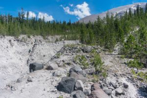
After the too damn steep climb back up to the Loowit, the trail continued its way up and over the lava flows. For a good while, first thing in the morning, I stopped seeing any of the cones. All of the way to Chocolate Falls, I found myself having to employ more technical route finding skills as I scrambled my way through the lava flow. The whole time, the air stuck. No breeze dared to make its way through despite the sun beginning to beat upon the dark rocks and cook the air around me. I noticed myself sweating more and more, but it didn’t seem like it was drying at all. I kept drinking my water and pushing forward.
In and out of lava flows, the hiking was difficult in the increasingly hot, humid as hell morning. Passing through some small meadow at one point, I noted even the dew on the plants wasn’t evaporating directly in the sun right there. And that’s about how I felt. Absolutely miserable. But the views. The views were so amazing. The trail itself, when it was even visible, was stunning, and it was like being stuck in a constant, living panorama, changing with every step. The cones did intermittently reappear, though, which helped.
And eventually the lava flow scrambling finally did give way to easier hiking, for the most part. Until I ran into a canyon I actually don’t know the name of. The trail takes a sharp turn, paralleling the canyon before dropping in via rope and climbing back up the other side via rope. Both ropes are steep–certainly requiring the ropes–and over super fine ashy ground that seems to give way under each foot.
As I descended the rope first, one moment my foot gave way and somehow in safely ensuring I didn’t fall, I ended up stabbing myself in the foot super hard with my trekking pole. That alone actually almost made the whole slip much worse, but I was already maintaining a death grip on the rope and really did nothing more than scare myself.
It was before climbing back up that I finally drank the last of my water. I had made the last liter last me about 3 hours. Despite drinking nearly 4 liters over the morning, I never felt better than the mild dehydrated I felt when I woke up. In fact, at this point, stomach cramps and nausea had already set in. I had been having a little headache for a while. The last bit of water was as unsatisfying as I would have expected such a small amount to be at that point, but I downed it and climbed up the rope.
I really, probably should have been more scared at this point. The closest water was 2 more miles away, and I was clearly not doing well. But there’s not much I could do, so I hiked on. The trail wound through light forest, although a constant, steady climb that felt like absolute torture. Somewhere in my head, I was thinking about the pain of every step as the blisters on my feet ached, my knees screamed with every move, and I was pretty miserable. But I laughed it off and kept going, until right at the Sheep Canyon trail junction I ran into a group of bikers.
Taking a rest to chat, one of the bikers also spared me some of his water, filling up one of my bottles. He put some kind of electrolyte solution in it that tasted just awful, but I was willing to take anything. It was still another mile and a half down the sheep canyon trail to the closest water, if I cut the hike short and skipped Crescent Ridge…
It wasn’t really a thought. I headed down sheep canyon, dreaming of the stream I had specifically noted and remembered spotting on Friday. Crescent Ridge will probably be there tomorrow. I needed water. Thankfully, it was all downhill, though, and quite easy.
At the stream, I jumped in, got wet all over, and grabbed another 3 liters of water, chugging as much as I could on the spot, despite nearly throwing up at the attempt. With a little more rest, I wasn’t feeling great, but I also wasn’t feeling like I was in active heat exhaustion any more, so I packed up and headed back on the Toutle Trail, back to the car.
As I remembered, there was one last, shitty climb at the end, but once I reached the Blue Lake Trail junction, it was just a victory walk back to the car. And this time, with wonderful views of the mountains and forest previously obscured by the fog and rain of Friday. It was a welcome reward, and felt like a surprisingly good ending to a difficult weekend and a difficult day.
Reflections
In total, I hiked somewhere around 37.5 miles, primarily on the Loowit Trail. There is technically 2.8 miles of the Loowit I skipped due to heat illness. I can’t regret any of that.
Did I mention that this hike is a brutal, grueling hike, but for all of that, it is even more beautiful, scenic, and just weird in the most awe inspiring ways? I quickly said that mile for mile, I think this is one of the most difficult and also most beautiful hikes I’ve ever done. I think I’m going to stand by that. I employed a lot more hiking skills than I expected to, and had to grow some I’m less good at. But I also took an absurd amount of totally justified pictures. Those that survived a review and post-work are really just the highlights.
Would I do anything different, though? Well, yes. Hopefully not get heat exhaustion. Plan out my water a little better. I was also not expecting that kind of humidity on such an exposed hike, and that was problematic for me in several ways. Caring for my feet became problematic much in the same, and that is certainly something to improve.
As for differences of just how to do the hike, I have a clear one: don’t do it the same day as those insane ultramarathoners. I actually enjoyed it, but I think it would be even better with some more solitude and not being interrupted by runners getting around me on the trail so much. It would add more adventure and challenge to some of the more difficult to follow pieces.
Going counter-clockwise would be an interesting difference as well. No matter what, the views are 360 degrees along the whole trail. Not turning around and looking regularly is a major disservice, regardless of direction. The no camping between the South Fork Toutle River and Windy Pass is the biggest hurdle in any direction and seems somewhat easier to manage going clockwise, but I didn’t really look thoroughly at counter-clockwise. Perhaps that’s a future version of this to do!
No matter what, this one is one I just want to come back to. I could do it exactly the same and I would still be happy to be out there doing it again. No hike is truly the same twice, but I would repeat this one before many other hikes I’ve done.
Pictures


1 comment
Comments are closed.