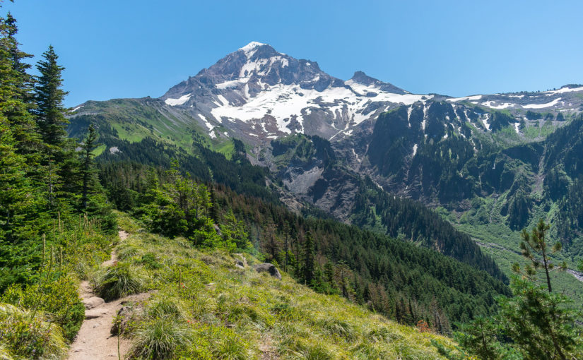
After backpacking around the Three Sisters, I decided that I really hadn’t had enough and wanted to get out more. Knowing that the Timberline Trail went around Mt Hood and was close, I decided to look it up. At about 40 miles total, as a loop, it would make for a wonderful weekend trip. And so, just 2 weeks after the Three Sisters, I hiked the Timberline Trail around Mt Hood.
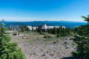
While preparing for this adventure, the popular route to go about it was to start at Timberline Lodge and hike clockwise. The weekend before, I drove up, looked around a moment, and decided this route looked pretty good. There’s also a nearby campground, with decent cell service, which I decided to stay at Thursday night, making the way to the lodge Friday afternoon easier.
The plan: Set out Friday evening, finish Sunday whenever I wanted. I got some idea of campsites for the 2 nights out but mostly just thought, “I’ll just go as far as I can each day.”
I really didn’t do too much to change my pack on this one from previous hikes. I cut my large Therm-a-Rest ZLite pad to the same size as the small and used some of the remaining to make a more consistent pad in the back of my REI Flash 22 pack. With the waistpack and other modifications, it all worked great, once again!
Day 1 : Friday
 6 miles
Finishing work in camp, I packed up and hit to the Lodge. Before 5pm, I was hitting the trail. Starting by dodging some kind of wedding that was getting started at the Lodge, I hooked directly up to the Pacific Crest Trail on the South side of the mountain and headed West.
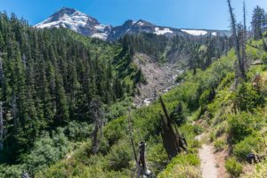
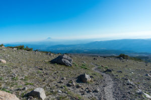
 Passing by the old Timberline Cabin site and into Paradise Park, it was a pleasant walk, really. Mostly downhill, and never too terribly steep feeling. The crossing of Zigzag River, really the first of the glacial stream crossings all around Mt Hood was really quite easy; I didn’t even get my feet wet. It made for a nice introduction to the mountain’s more wild side, however.
After crossing the Zigzag, I quickly found my way into Paradise Park. I walked about a quarter mile up the Paradise Park Loop Trail, but I was thinking of camping along the PCT, so I turned back and continued along.
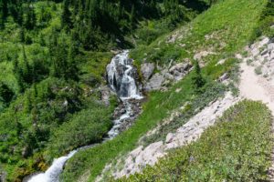
 It wasn’t long before I came across a creek, with my GPS telling me, by a gpx map I had preloaded off of the internet, that there were some campsites nearby. As it turns out, I was able to find one, although it doesn’t seem like it is really that great of a campsite. Better campsites were within just a mile down the trail. But I went to sleep staring up at a waterfall cascading through the lush forest. It was nice.
Day 2 : Saturday
 22 miles
Sometimes, I find myself humorous with how quickly I will take to life on the trail. Waking up as twilight said its last goodbye, I was packed up, breakfast in my stomach, and on the trail before 7am once again. It helped knowing I could have a long day ahead. I projected up to 24 miles, if I really felt like pushing it, but I also just wanted to let myself hike and enjoy it as I do, so I wasn’t really too focused on getting to any one spot. Just try to get as far as I could for the day…
 The day actually started out really nice! It was a pleasant hike down, with the occasional awesome view, down to the Sandy River crossing. By the time that I got to there, the sun finally started peaking out over Mt Hood from my angle, and a few other backpackers pointed me upstream to the pretty damn easy, dry crossing across a couple small logs.
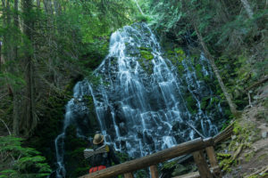 From there, once I found the trail on the other side again, I continued onward to a wonderful stop at Ramona Falls. It was dark enough in the forest still that I couldn’t wear sunglasses, and getting pictures required screwing around with exposure and aperture a bit. But pictures could never do justice to this area. Usually, the Timberline Trail continues up to Bald Mountain, but I decided to take the route back down to the PCT via the Ramona Loop Trail on the northern side. That area follows along a small creek, through thick, remarkable forest. It was yet more pleasant start to the day!
And then it began. After clinging to a rope to cross a massive downed tree across the Muddy River, the climb ensued. Just the climb on the PCT up to Bald Mountain was surprisingly tiring. Of course, I still had a heavy pack, full of a day’s worth of water and 2 more days of food. But I kept tredging along.
At the top of Bald Mountain, the Timberline and the PCT split, so I stopped to take a break. There’s also apparently a trailhead right there and I was surrounded by day hikers the whole time. Actually, I wasn’t really alone much this whole hike. But at least most were friendly and welcoming on the trail. I just dislike crowds sometimes!
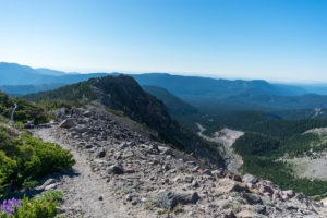
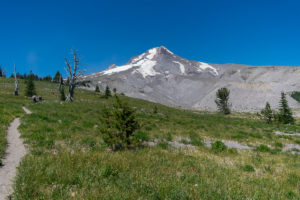
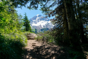 And from Bald Mountain, the climb wasn’t over. Up to Cairn Basin, the Timberline follows a surprisingly cool ridge higher and higher and higher. Views along the ridge were mostly blocked by trees, but sometimes, Mt Hood would pop out from behind the trees and looking stunning as hell. Although grueling, I was still actually quite enjoying the hike!
 Around Cairn Basin, I actually started meeting and talking with some other backpackers. I would hike along with a few of them intermittently throughout the day, helping each other across some of the more difficult stream crossings and being kind strangers. I purposefully dropped behind or tried to pull ahead on my own a few times, craving that solitude that’s damn near impossible on this trail, but it was all just a wonderful time either way.
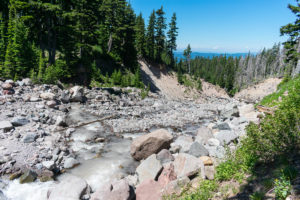 Making my way through to Elk Cove and across several more stream crossings, none were actually too bad. Several seemed quite sketchy and required careful footing. The Coe was notable, but I ended up still able to cross with dry feet. The occasional creek of mostly snow melt was wonderful for filtering water along the way (although I started with way more than I needed for the day anyway), but the big glacial streams were milky and remarkably silty. I actually found the contrast quite entertaining.
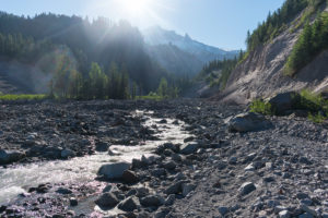
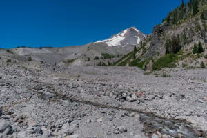
By the time I reached the Eliot, it was approaching 6pm. And the Eliot is notorious. I saw a picture of it at the ranger station, but I had no perspective. As I walked down the new trail to a new crossing, the size of it actually rather impressed me! And it was raging…
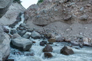 Making my way onto its banks and the most obvious spot for crossing, I stood and considered my options. A waterfall just upstream and a rush downstream, it’s not one to take lightly. Although I’m including a picture of the Eliot here, it doesn’t show where I crossed, unfortunately. I actually crossed basically where I was standing taking the shot. At this point, I noted a series of rocks that were not quite a jump away from one another, but would take large steps. It was this or try grasping around much larger boulders that didn’t look so inviting to me. So on I went.
Stepping onto just the third rock in the series, it seemed okay. I shifted my weight and started moving my other foot… my footing slipped entirely. Down I went, right into a cascade dropping into a long slide down a steep, rocky slope! Thankfully, I had, in a state of paranoia, planted my trekking poles firmly into the ground before making the move, and was able to catch myself. Too caught up in the moment to really fear the possible damage to the poles, I used the momentum of the falls and the stability of the trekking poles to swing back up and just start jumping through the crossing, determined to get to the other side. Five or six leaps through the water, and I was out! My feet were absolutely soaked. My socks–I was wearing long boot socks, too–were absolutely drenched from being completely submerged over and over. But I had made it! I screamed at the top of my lungs at the damn river and found a place to sit and collect myself.
Immediately following this, of course, was the climb up to Cloud Cap. Demoralized from feeling far too close to death at that crossing, I pushed on, but seeing an open campsite at Cloud Cap, I gladly paid the fee and stopped for the night. It was still a little early; I could have kept going. But the rest was welcome, and I enjoyed the night at the campground.
Day 3 : Sunday
 15 miles
Once again, I hit the trail early. This time, I knew I still had yet to hit the highpoint of the whole Timberline Trail, and at 15 miles to finish the day, it wasn’t going to be too easy. But I slept alright, and with some good rest, I was ready to hit the trail.
 Probably the most alpine area of the whole hike, I climbed up to Cooper Spur Shelter right away in the morning. From here, the cold winds contradicted the amazing views all to the North and East, especially. The views would continue all morning as I climbed through the alpine area, over snow fields and finally hitting the high point of the whole trail. And then it was…
 Well, it was down some pretty incredible downhill for a while, at least! Down Gnarl Ridge to Newton Creek was actually some of my favorite views and favorite hiking of the whole trip. And on the other side, the waterfalls of continuing creeks and stunning meadows were quite wonderful themselves!
 Around Mt Hood Meadows, one thing did really start to suck, though: the flies! Trying to stop for a break at all, and the flies were everywhere. I had treated all of my clothes with permethrin, was using picaridin lotion, and cover myself up mostly with clothing… none of it mattered. The flies just sucked. It was difficult to stop long enough to even get food out, let alone actually eat any of it. But at least the meadows were beautiful, the flowers were pleasant, and the views magnificent. Getting to the White River and finishing this hike was seeming better and better, though.
 And I did get to the White River. A pleasant drop into its washout on the Eastern side, I actually even decided to just take off my shoes and wade through. The sand in between different branches of it at this spot was hot as hell, but I didn’t care. It actually felt quite nice on my aching feet, and I was only going to be happier that I had.
 Coming out of the White River, I had incorrectly sold myself on the line of, “And it’s the last couple of miles, and they shouldn’t even be all that bad!” But hitting this part of the trail at mid-day meant lots of exposure to the sun, and I wasn’t quite prepared for just how much of a climb it was! Or the fact that it was almost all in what might as well be described as grass covered sand dunes. A couple who had hiked the Timberline Trail the year before congratulated me as I suffered up the hill, which helped, but it sucked.
Finally, Timberline Lodge came into view and after far too long of further hiking, I came out just above it. Heading down, I bought a drink in the lobby and headed out to the car. I had finished hiking the Timberline Trail.
Reflections
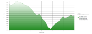
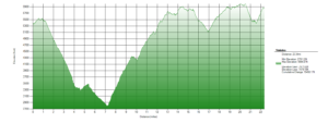
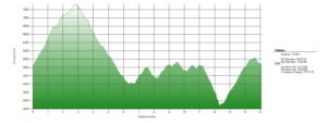
In total, my mileage came out to just under 43.5 miles and over 14,000ft of cumulative elevation gain. One hell of a hike!
The biggest con of this hike is the amount of people out there, on it. I didn’t have any unpleasant encounters. There’s just a big lack of solitude on this hike. However, I didn’t mind it all too much. I had gone in with something of an expectation on this anyway, so I wasn’t heartbroken.
That said, for all of the people, the trail feels particularly rugged and wild. Some of the creek crossings have had seasonal bridges in place in the past, but many have washed out and not really been replaced, resulting in plenty of danger and excitement. The trail is well defined and easy to follow, but relentless and somewhat unforgiving. 40 miles is a lot to do in a weekend, too.
If I was to do this one again, I would be tempted to make sure I’m hitting the Eliot a lot more fresh than I did this time. Starting at Cloud Cap and going counter-clockwise would be one option. It’s also a good bit more uncommon. There’s other trailheads that could be used as well. However, Timberline Lodge is a wonderful place to end, really, and that’s hard to beat, so I would have to weigh it. I am glad I did it this way this time, but some alternatives do have truly intriguing pros of their owns.
Pictures


So impressed, both with your hike and your coverage of it. Unable temporarily to hike, even barely walk, due to physical problems, but share your desire for solitude in the wild. It’s one of my favorite aspects of exploring Agua Fria National Monument where I had a very short talk with you some time ago. Keep trekking and continue to share. You are an inspiration.
Thank you. That sucks! I hope the problems get better and you can get back out there again!
Beautiful hike !! and Photos ! Pretty impressive mileage I would say.
Thank you. The days being long and getting up early definitely helps, though! It’s definitely a tough one to squeeze into a weekend, either way.