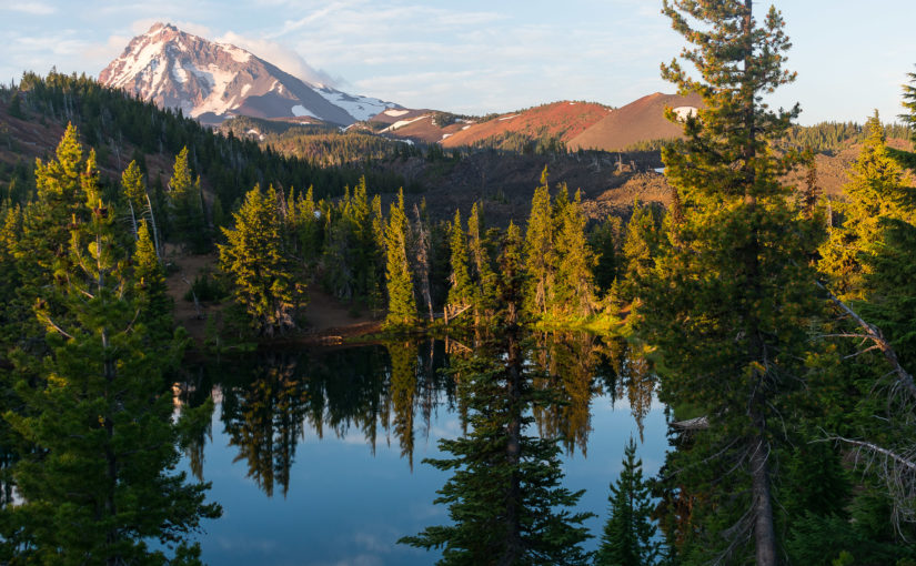
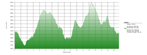
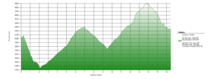
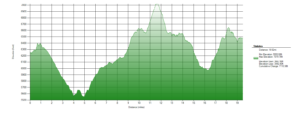
For July 4, I had a total of 5 days off to do what I wanted to do with, so I decided to find some good hiking in the area. I took those 5 days to hike the Three Sisters Loop, in the Three Sisters Wilderness, Oregon. The loop itself is some 45 miles or so, but with side-trips, including a summit up South Sister on the final day, I completed over 80 miles on the trail.
Prep
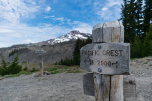
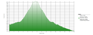
The Three Sisters are a small group of volcanoes in Central Oregon, lying on the Pacific Crest. To their West side, the Pacific Crest Trail passes by, and by utilizing this and a few trails making their way around, it is possible to circle the Three Sisters. The loop itself comes out to about 45.4 miles (per my topo map), in addition to any side trips and the way to the loop itself (the loop does not come directly to a trailhead itself, but it is a short way from several).
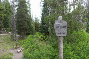
While researching, I read a lot of people noting the Obsidian Limited Entry Area with confusing directions. When I went into the USFS ranger station, I was advised that a permit is needed regardless of what trails you stay on while passing through the area (the PCT’ers just have to stay on the PCT with their normal PCT permit, whereas the rest of us all need a specific permit but will be able to explore the other trails). I got a day use permit for the day I planned to pass through and it worked out great for me.
Pack
I took a slightly updated version of the same pack that I took on my SDTCT hike. Again, I went with the waistpack combined with a lightweight daypack. In fact, I used the same day pack–an REI Flash 22 with modifications. However, I did change a few things.
Instead of a blow-up mattress, I brought a regular sized Therm-a-Rest ZLite Sol. After spending 4 nights with it, it is not quite as comfortable, but it is more comfortable than a flat air mattress, so there’s that. For 14 ounces, it is kind of unreasonably long, and I’m going to cut it down on for future hikes, I think. Nonetheless, it worked great for this one, and I think I’m going to stick with the “egg carton” variety over the blow-up kind for the majority of the future.
As the waistpack I took on the SDTCT was broken, I picked up a new one: a Mountainsmith Drift pack. This one doesn’t have the extra small pockets along the waist strap, but overall, it does hold more, easier. I was able to hold my tarp in the waistpack, along with several other pieces, for a total baseweight of 2.78lbs in that pack alone.
Finally, I didn’t bring some of the warmer clothes that I had brought on the SDTCT, as I didn’t even need them then and the weather looked (and was) pretty nice the whole trip. Instead of a 2L PlatyBottle, I also just brought 2 extra 1L Smart Water bottles, and I found that I actually like this system more. I didn’t bring any extra bowl or my spork (the latter was kind of an accident, but it wasn’t necessary).
In total, the baseweight for this pack came out to 8.09lbs or so. Nice and light, but full of everything I need. Including a goddamn pillow.
The Hike
Day 1
16.37 miles
 Waking up early camped out nearby, I cleaned up camp and headed to the Green Lakes Trailhead. By 8:30am, I was headed out on to the trail. It wasn’t long at all before I was a mile down the trail and suddenly realizing everything I screwed up. Forgetting my spork was just stupid, but easy enough to just use a small spoon out of the tuna packets I brought along. A few other things just forgotten to do beforehand or just forgot back in the car on accident, but nothing too major. Just enough to make me stop and exasperate about what I was going to miss on the trail.
I didn’t actually look at my GPS until well down the trail, and then I realized that I had completely forgotten about putting any topo maps and trail outlines on my GPS. Of course, I had been reading that there was tons of snow in a couple of sections and that GPS was nearly essential. But that was like a week ago, and what the hell? I had a good paper map and I did have the GPS to help position me on the map, if it came down to it. I decided to just do the hike by paper map and the small (not very good) compass I keep on my watch strap. Everyone that goes out in wilderness should learn to do this, practice it regularly, and be prepared to do it at any given time anyway. But I don’t even bring along one of those emergency satellite devices. I guess I’m a little bit of a purist at heart. I do take my phone and check service and send out a text message or more commonly just post something on social media when I can, mostly to ease the minds of those not on the trail. It’s completely useless when you don’t have reception, though, other than maybe as a side camera, and I don’t really have or use any useful hiking apps. In fact, on this one, I forgot to charge my phone and had to turn it off all but once a day to check service or take a special picture. I can’t necessarily advise it… being like me is technically more dangerous and more difficult, for sure. I think there is inherent value in that, so it doesn’t bother me. I was actually excited by the prospect of what this meant for the hike ahead!
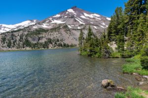
 From Green Lakes Trailhead, I had decided to take this one clockwise, so I cut over directly to Moraine Lake. This was my first lake of the trip, and it is a pleasant one as I made my way across the southern side of the mountains. Much of the southern side is open alpine area with spotty plant growth. It’s actually pretty interesting in its own ways, I think. I enjoyed the rolling hills and the almost other-worldly feel of it.
 Finally, as the PCT came up to Rock Mesa, I jumped onto the PCT and began heading North. Rock Mesa is actually a pretty cool, huge lava dome. The size of it is really rather impressive as you walk next to it, and I stopped to enjoy lunch along its edge. From here, most people might just continue on the PCT all of the way to the Matthieu Lakes, but not me. Shortly after Rock Mesa, I was off to other adventures.
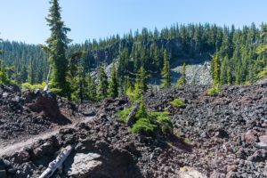
I set off down a side trail, headed towards Honey Lake for the night. Or so was the goal. I first missed the turn towards Honey Lake, of course, but thankfully, it didn’t take me long at all to realize it and turn around. As I began down the trail towards Separation Creek, however, the trail became quite rough. I kept going regardless. Shortly after Rock Mesa, I had begun going in and out of burn scar, but this section proved to be the worst of all.
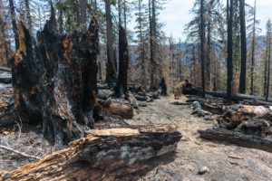 As I walked down the trail, the trail suddenly disappeared into some of the roughest burn scar of the whole day. Bad enough that the trail seemed to suddenly disappear. A couple of other foot prints seemed to be around, but difficult to follow. Some elk footprints were clearer as the trail completely vanished and I found myself standing in a pile of ash in the middle of the burn. Like some kind of moron, though, I figured I would climb up a small hill right next to me to get a vantage point and figure out what the hell was going on.
Aside from almost falling and scaring the hell out of myself as the burned ground gave way under me a couple times, I made it to the top of the hill. But alas, the trail was obscured to me. I had some suspicion this is where not having a good GPS track failed me, especially not having ever been down there before. Without any of the above, I decided to give in and turn back. After looking at my map, I picked out Husband Lake and headed there.
 Thankfully, the way to Husband Lake following this was pretty much uneventful. More burn scar sucked, and the trail wasn’t always too easy to follow, but nothing so bad as to send me turning back. Not even any significant snow to navigate through/around. Ultimately, it ended up being more miles than I intended on the day, but I found a great campsite near Husband Lake with a view of Middle Sister and called it a day.
Day 2
16.83 miles
Waking up early, I hit the trail before 7am again. I hiked by Eileen Lake and headed back to the PCT, about 5.9 miles north of where I had left it.
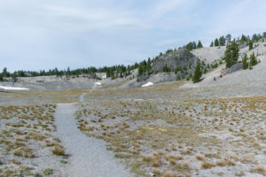
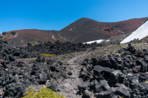
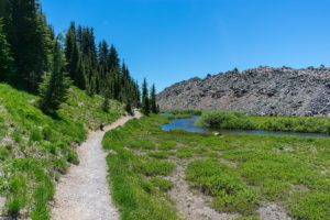
Less than 2 miles later, I entered the Obsidian Limited Entry Area. Again, I really didn’t research what I was going to walk into here, but I had some reasonable expectation that there was some obsidian around. In fact, there is. Hiking on the trails off of the PCT, I came down to a point in which a large red-ish lava flow was in front of me and the Obsidian Cliffs on the other, as I stood in a pretty wonderful meadow.
 Climbing up the lava flow on the main trail through the limited entry area, I enjoyed the views and even stopped to eat an early lunch. I am a huge fan of lava flows like this, and the cool red and black colors of this one was fun to hang out in as other hikers came through. I did decide to turn back before making it too far and headed back towards the PCT.
On the way back North again, I took the Glacier Creek trail. Somehow, that actually feels like it was appropriately named, because this was probably three quarters snow fields as it climbed back up to the PCT. It felt like nearly all of it was. And being quite steep, I was ready for and indeed took a break as soon as I got to the PCT, before heading on.
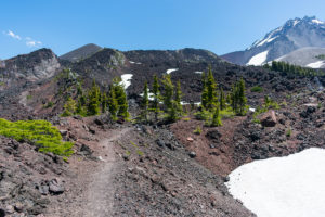 Next up on the PCT was Opie Dilldock Pass. Aside from having fun with that name (“Happy Dildo Pass”), as I came up to it, I was really quite impressed. Again. I love lava flows. And this pass is basically a big climb up some crazy lava flow into and kind of through some cinder fields.
 Of course, coming up to the biggest climb of this pass, I had a moment of “Oh shit! I have to climb THAT right now?!” It’s basically a tight series of switchbacks up a really interesting spot in all of this lava flow. Alas, up at the top, staring back at an amazing view and the intricate cinder fields ahead, it was totally worth it! This was actually probably one of my favorite spots along the whole hike, and exactly what I was really hoping to find doing this hike.
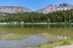
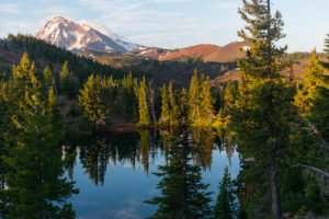 For nearly the rest of the hike to South Matthieu Lake, I just enjoyed the wonderful views and cool volcanic things to look at along this piece of the PCT. And as I got to South Matthieu Lake, which has managed camping, I actually found a campsite at the first place I looked, complete with a nice view over the lake and on to North Sister. The day was tough, but a great day of hiking!
Day 3
16.48 miles
Waking up to the gorgeous views at South Matthieu Lake, I packed up and headed back South. Just south of the lake, I headed down Scott Pass Trail, where I continued on to Green Lakes Trail, headed south.
This section. This whole section of trail. Almost this whole damn day. It sucked. Not because it was physically difficult. It was: 16.48 miles will always be tough. But it was also actually one of the calmest days in terms of climbing. More importantly, the vast majority of the day was spent hiking through burn scar. The trail was easy to follow, as most of this is older burn scar. Being surrounded by so much death, the lack of shade from the sun, how dry the air is in these areas, and just the general drag of such a slog through burn: it certainly wore me down not only physically but mentally and emotionally, most importantly of all.
 I couldn’t have been more happy to make the turn up towards Camp Lake and finally get out of the burn scar after another mile or two of hiking up. Crossing one glacial stream that was a beautiful glacial blue in color that night, I continued on to the higher trails, with some absolutely amazing views of North and Middle Sister along the way.
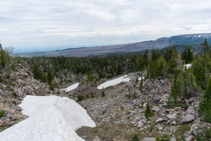 As I came into the higher reaches of the trail, I suddenly ran into a huge snow bank blocking the trail. Some footprints climbed over one side of it, and I decided to follow those footprints to see what would happen. It really didn’t feel safe, and in getting to the top, I couldn’t find the trail on the other side, either. Stopping to take a couple of pictures, because I’m apparently insane or something (or I’m just exaggerating; I’m not telling), I climbed back down and decided to head back down the trail.
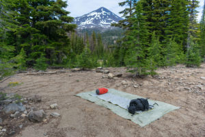
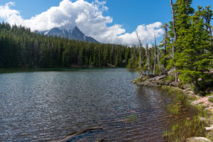 Thankfully, close by was Demaris Lake, so I decided to make the way down there and see how the camping was. As it turns out, I was able to snag a wonderful campsite with a couple of amazing views and not many bugs (other parts of the lake had terrible bugs!). Right as I began setting up, a couple of groups of other hikers made their way in as well, but never making enough noise to bother.
Day 4
19.52 miles
Waking up at Demaris Lake, I wasn’t really excited to get going. I knew that the beginning of the day would be dominated by burn scar once again. Still, I forced myself up and hit the trail.
Originally, I made a plan to filter some of that glacier blue creek water I had crossed the day before. Well, I would do this anyway, but when I arrived again, the water was a silty brown instead. Filtering it, it still tasted pretty delicious, and the water was so cold, it nearly numbed the hand holding a water bottle under it to fill. I could have gone for some of how it looked the night before, but oh well. On down the trail I went.
This time, in the burn scar, I ran into 2 black tail bucks hanging out, munching on some of the light undergrowth that has started growing back already. I wasn’t able to get a good picture of them as they kept moving, but I enjoyed seeing them. About 5 minutes further down the trail, there was a doe as well. The doe was much more skiddish and ran off before I could even grab my camera. Still a much more enjoyable experience than the pure death of the day before.
Back on the Green Lakes Trail, after some miles, I finally ran across a sign posted on a tree declaring that I was leaving the burn area! I don’t know if anyone else was near on the trail at that time, but if they were, they certainly heard me taking a moment to celebrate! The rest of the day would be spent surrounded by life, and I couldn’t be happier about that!
Of course, I’m not one for taking many pictures of forests. It was a cool forest. I tried a couple, but I just really don’t like them so I’m not posting them up here.
 The pass up and over to Green Lakes was one of the larger climbs that I had done yet, and finally reaching Green Lakes at the end was amazing. Of course, the area was full of day hikers, too, which was actually somewhat jarring for just how many people were there. Nonetheless, I really enjoyed the variety of views all along the lakes as I stopped to eat lunch and make up my mind about what I wanted to do.
 I had originally planned to just stay at Green Lakes that night, but I arrived just after 1300 and definitely felt like I had more hike in me yet. After talking to a couple of forest service rangers that were making their way through the area, I decided to continue on back to Moraine Lake to try and find a campsite for the night.
 This last section of the Green Lakes Trail followed another large lava flow and a creek that runs alongside it. I found it a really gorgeous place to hike through, even though it was really crowded with day hikers. Alas, continuing down it, I turned onto the familiar Moraine Lake Trail and headed to Moraine Lake.
Arriving at Moraine Lake around 1600, I came in to find most of the designated campsites–the only campsites allowed in the area around the lake–already taken and I wasn’t alone in looking for somewhere to stay. Thankfully, I found a small, designated spot tucked into some trees and turned in for the night.
The loop was technically complete at this point, but I wasn’t ready to get off the trail yet, even though I easily could have, being so close to the car. First, I needed to climb one of these damn mountains…
Day 5
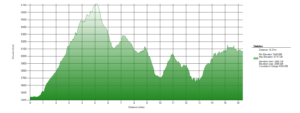
14.06 miles (over 4500ft of elevation gain)
 With the loop completed, it was time to summit South Sister!
 I woke up naturally early, as usual, packed up, and hit the trail. After about a mile of familiar trail, I turned up the South Sister Climbers Trail. This begins on the rolling alpine hills as surrounds the general area before turning steeply up the mountain. It was actually quite a pleasant start to what would become much more grueling.
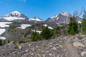
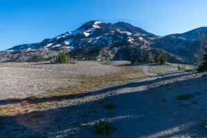
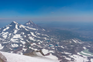
 South Sister is actually my first stratovolcano to summit, and I didn’t really know what to expect. The variety of rock and variety of difficulty in the terrain was somewhat clear just from looking at my map and knowing it was going to be tough. However, it’s basically just a straight trail all of the way up. Starting in the rolling hills, it turns into the light colored rock, with steep switchbacks and snowfields to navigate that would feel at home in just about any mountain range.
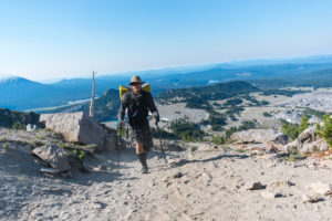
The higher I climbed, the greater the views got. But the trail also got more and more steep and more and more difficult to climb. At a certain point, all of us hikers on the mountain began to notice that wildfire smoke began to blow in and huge swarms of butterflies began flying up the mountain. The whole thing was a bit of a trip, but I thoroughly enjoyed the climb.
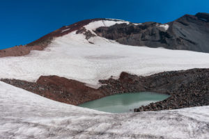 Cresting just below the Lewis Glacier, I had to take out my leggings and jacket as the wind began to have a bite to it in the air. The remainder of the hike in view became remarkably daunting, especially as I sat watching people making their way, very very slowly up the rest of the trail. Like little exhausted ants, the red, loose rock of the next section even looked like they were climbing a large ant hill. It was pretty cool, although intimidating.
 And onward I continued.
This part of the hike really sucked. The way was ridiculously steep and the ground was loose and felt sketchy nearly the entire way. At the high elevation, the little bit of smoke reaching the air irritated my dried out throat and made me stop and cough.
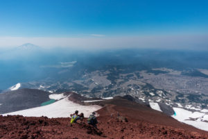
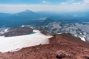
 Finally, the trail crested on a false summit. I wasn’t even mad. A nice windbreak had been constructed right there, and I stopped to rest before making way around the summit crater to the true summit on the opposite side. And, of course, the true summit was entirely worth it in its own way!
 And so, finally, the hardest part of the whole hike was over! After spending a bit on the summit, I headed back down. The same trail was difficult on the knees going down, constantly catching myself from sliding too far and just dealing with the steepness of it. With my knees, this meant me going slow for quite a while. Thankfully, the wildfire blew back out, the views cleared up a bit more, and the way down was a lot more enjoyable than I even feared from the difficulty of the way up.
And the finish was completely uneventful. Coming down South Sister, I stopped at Moraine Lake one last time to get some water, and headed back to Green Lakes Trailhead. The hike ended.
reflections
This was an amazing hike! I’m really glad that I did this one. I love volcanoes, and everything about the volcanism around this hike was very exciting for me. In many ways, this is probably one of, if not easily the best hike I’ve done for volcanoes. Certainly considering this is really the only time I’ve spent this much time in volcanoes alone. This is all just exciting to me and I’m still pretty stoked on it.
If there was anything I would do differently… I’d actually do it backwards. Starting from Green Lakes Trailhead, I would go counter-clockwise. Get the crowds of Green Lakes out of the way, and then deal with that shit burn scar before being rewarded with the loveliness that is the West side of this hike. It would also reduce how I did one 2 mile section 3 different times to just one time. It’s not that exciting of a section of trail, although it is cool.
Doing this over July 4 meant a lot more time in camp in the daylight than I usually do. I already wake up early this time of year, and the sunrise wakes me up easily when backpacking. So I would hit the trail before 0700 every day–sometimes before 0600! This resulted in me often doing 12 miles before noon. I got into camp before 1630 every day, despite feeling like I was actually going a slower pace than usual and the sun not setting until closer to 2100. If I had been more actively hiking, it would be easier for someone like me to pop out much larger days than I did. It could be interesting to consider other side trips and those longer days.
In conclusion: A fucking great hike! I’m really glad I did this one and would absolutely do it again.
Pictures


1 comment
Comments are closed.